Next
Previous
Index
pscontour for direct contouring
Find sample data files and scripts in /GMT_data/budo01
makecpt -Ctopo -T970/1010/0.5
> budo.cpt
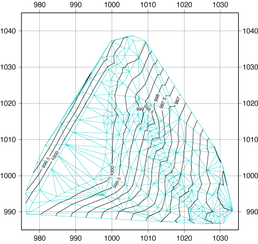
pscontour xyzm.prn -R975/1035/985/1045 -JX15 -Cbudo.cpt -L0.5/0/200/200p
-W0.7p -P -B10g10 > budo1.ps
makecpt is to create a color palette file using ready-made color setting
(topo) and
-Tzmin/zmax/increment. Output file is budo.cpt.
pscontour sets up triangulation network and draw contourlines in the network
directly.
-L defines stroke of triangles. Color palette file is used to define
the contours to be drawn.
If necessary, enlarge this and check each triangle fits to real topography.
Triangulation error: For example in the map below, assume (980, 1040,
1002), (990, 1030, 1002),
(980, 1030, 998), (990, 1040, 998). In this case, there is no way to
distinguish if there is
1002 m ridge between (980, 1040, 1002) and (990, 1030, 1002) or 998 m trough
between
(980, 1030, 998) and (990, 1040, 998) unless the height of (985, 1035) is
known. Check and
change triangulation adding (985, 1035, 998) or in the field, measure any
linear features in
smaller interval to avoid this problem.
Next
Previous
Index