![[IMAGE]](geredect.jpg)
1939--1967 rupture history of the North Anatolian fault and GSJ-MTA trenches
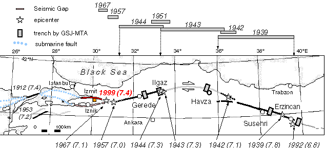
[abstract] The North Anatolian fault is an important laboratory for substantial segmentation of a strike-slip fault. The series of faulting events during 1939-1967 is one of the most striking observed example of fault segmentation on land. About 850 km of the strand faulted in 3 gigantic (1939, 1943, and 1944) and 3 fairly large (1942, 1957 and 1967) earthquakes with westward epicentral migration (figure 1). Comparison of this series of earthquakes with previous ones should be a key to understand the behavior of strike-slip faults in time and space. However, geologic information on the past activity of the fault has been very limited until late 1980s when detailed survey of recent ruptures including exploratory trenches is introduced to Turkey. At the same time, historic documents were so sparse that only a few events of 1668 A.D. (Ambraseys and Finkel, 1988) and of 1784 A.D. (Barka, 1992) and a few periods of higher activity (Ambraseys, 1975) have been inferred. Turkey-Japan joint research on the paleoseismology of the North Anatolian fault began in 1989 and has investigated three segments of 1939, 1944, and 1784? [There has been no surface faulting in this century according to Barka(1992).]. Now for the first time, it is being possible to compare time-series of surface faulting events on different segments. In a trench east of Gerede (40°49'23"N, 32°20'27"E) on the 1944 (Bolu-Gerede) surface fault, we recognized 8 earthquake events since around 30 B.C. Average recurrence interval is estimated to be between 200 and 300 years (figure 2). On the 1784? surface fault, a trench east of Erzincan (39°36'21"N, 39°51'23"E) showed 5 events during these about 1000 years. According to 30 radiocarbon dates, the estimate of the average recurrence interval is between 200 to 250 years. On the 1939 (Erzincan) surface fault, a trench was opened near Susehri (40°02'46"N, 38°33'44"E) in 1993. We recognized two events in the trench and now dating is under way. Comparing the result from 1944 fault with that from 1784? fault, the timing and the recurrence interval of faulting events in these two segments are probably not the same. This may mean that the westward migration in this century is just a coincidence, or that each segment has different rupture history. Another possible explanation is that in 1784? trench occurence of fairly large earthquakes like 1942, 1951 are recorded in addition to the gigantic ones, while the Gerede trench showed only the gigantic ones. Higher resolution in time will be the key to answer such question.
![[IMAGE]](erzincan.jpg)
[abstract] Although the 1992 Erzincan earthquake did not generate any tectonic surface rupture, it raised questions about the paleoseismology of the North Anatolian fault in and around the Erzincan Basin. During the 1939 Erzincan earthquake, fault rupture did not reach further east than the Erzincan Basin (Ketin, 1969). Barka (1992) supposed a 75km long segement east of the basin has been quiet since 1784 A.D. In order to evaluate the supposition, we excavated the western end of the inferred seismic gap approximately 30 km east of Erzincan city. 3 meter deep trench exposed sequence of stratified fine sediments of these 1200 years. We identified five horizons of coseismic deformation indicated by incremental tilt of peat layers, deformed fissure, and paleoliquefaction. Our preliminary estimation of the age of the last event is 17 to 19 c. A.D. consistent with the possible 1784 A.D. last event. Average recurrence time is estimated as 200 to 250 years. The 1939 surface rupture probably did not reach the trench site. The age of each event does not agree with the age estimates of events on the 1944 segment (Okumura et al. 1990). There might have been one more event on this segment than 1944 segment during this millennium, which indicates either overlapping of the surface ruptures on the two segments or higher activity in the eastern part of the North Anatolian fault than the western part. Paleoseismological data might suggest that the epicentral migration in this century had not been repeated.
[abstract] Although the 1992 Erzincan earthquake (1992. 3. 13, Ms+6.8) did not generate any tectonic surface rupture, it raised questions about the paleoseismology of the North Anatolian fault in and around the Erzincan Basin. During the 1939 Erzincan earthquake (1939. 12. 26, Ms+7.8), the fault rupture did not reach further east than the Erzincan Basin. Recent study into historic records indicates a 75km long segment east of the basin has been quiet since 1784 A.D. In order to evaluate the supposition and earthquake potential of the area and to reveal the segmentation of the fault in time and space, we excavated two trenches near the western end of the inferred seismic gap approximately 30 km east of Erzincan city. At the trench site, the fault displaces an alluvial fan surface to dam up fine sediments with upper-reach facing fault scarplet. A 3 meter deep trench and another 1.5 meter deep trench exposed sequence of stratified fine sediments of these about 1200 years. We identified five horizons of coseismic deformation indicated by incremental tilt of peat layers, deformed fissure, and paleoliquefaction. The sediments appeared in the trench bore a number of datable material in almost all horizons. 30 samples among all 50 samples collected were submitted to radiocarbon dating, including 17 AMS dating. Our preliminary estimation of the age of the last event is 17 to 19 c. A.D. consistent with the possible 1784 A.D. last event. Average recurrence time is estimated as 200 to 250 years. The 1939 surface rupture probably did not reach the trench site. The age of each event does not agree with the age estimates of events on the 1944 segment, where 8 events were dated since 0 A.D. There might have been one more event on this segment than 1944 segment during the last millennium, which indicates either overlapping of the surface ruptures on the two segments or higher activity in the eastern part of the North Anatolian fault than the western part. Paleoseismological data might suggest that the epicentral migration observed in this century had not been repeated itself and recurrence time might be different from segment to segment.
![[IMAGE]](geredetr.jpg)
[abstract] We excavated the North Anatolian Fault on the surface rupture of 1944 Bolu-Gerede earthquake and surveyed micro-topographic evidences around the site to get geological data on recurrence intervals of large earthquakes and slip rate, both of which have long been undetermined. The site was located at 40d49m23sN, 32d20m27s, between Ismet-Pasa and Gerede, where the fault runs across a marsh in front of concurrent alluvial fans developed on the bottom of the fault valley. Stratified deposits consist of fan conglomerate, marsh or lacustrine deposits with much organic material, and flood deposits appeared on the trench walls (12 m across the fault and 3 m deep). The age of the deposits is younger than 2,000 14C yr. B.P. The fault branches upward to form a wedge-shaped fissure less than 1 m wide and filled with collapsed/dragged sediments between slightly deformed sediments on both sides. We recognized 5 discrete evnets evidently and could infer 1 or 2 more events indirectly from the thickness and the distribution of sedimentary units. The average recurrence intrerval is preliminarily between 300 and 500 years. Further details including the estimation of slip rate are to be reported with more 14C ages.
E-mail: kojiok@ipc.hiroshima-u.ac.jp