South America Workshop on Paleoseismology
on the Bocono fault, Venezela [February 1997]
Fault topography and trenching survey
near Lake Mucubaji, east of Apartaderos
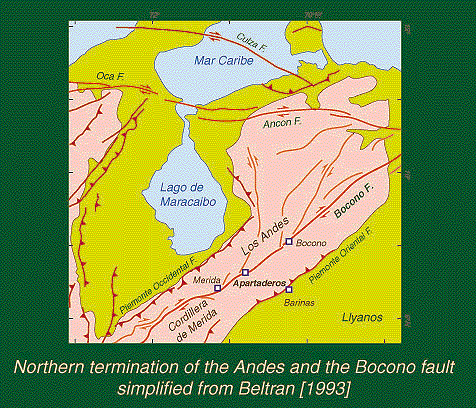
Figure 1. Active faults in and around the Northern termination of the Andes.
Abstract for IASPEI meeting 1997
Geomorphologic and Trenching Evidence for Surface Faulting on the Central Part of the Bocono Fault, Venezuelan Andes
South America Field Workshop on Paleoseismology (SAWOP)
(Group contact: Franck Audemard, Funvisis, Caracas, Venezuela
+58 2 257-7672; faudem@funvisis.internet.ve)
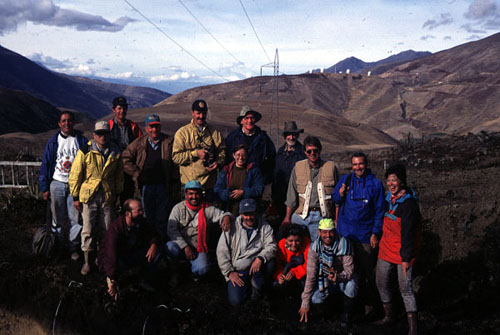
The recent South America Field Workshop on Paleoseismology (SAWOP) in the Venezuela Andes was organized by ILP Task Groups II-2, II-3, and II-5, in collaboration with Funvisis with the support of GSHAP and the EC project PILOTO. The international workshop taught paleoseismology to participants from South America countries using a field classroom where we could collect new data and contribute to the understanding of the seismic behavior of a major fault in South America.
The workshop target was the Bocono fault, 60 km NE of Merida, in the central Venezuelan Andes. The Bocono is a spectacular NE-SW trending, dextral strike-slip fault that extends for about 500 km forming the backbone of the Venezuelan Andes. Several large historical earthquakes in the Andean region have been attributed to the Bocono fault; recently some of these have been associated with specific parts of the fault through paleoseismological investigations. The Merida region was devastated by an earthquake in 1812 that may have ruptured through the section of the Bocono fault investigated by SAWOP. This section of the fault has two conspicuous late (?) Holocene fault strands located about 1 km apart: the southern and northern strands probably carry 25% and 75% of the slip, respectively. Offset of moraines of the last glacial period (ca. 15± 2 ka) on both strands suggest a net slip rate of 6-10 mm/yr for this part of the fault. SAWOP excavated a trench on the northern strand of the fault (near Morros de los Hoyos) across a twin shutter ridge and related sag pond that was surveyed in detail using an EDM. The trench exposed two main fault zones mainly in clay, sand and gravelly alluvium. Each zone forms a shutter ridge with peat deposits ponded against the uplifted block. The 19 participants found a general consensus for two or possibly three surface-faulting earthquakes. Radiocarbon dating of peat samples is underway to provide preliminary constraints on the timing of the most recent and penultimate events on this strand of the Bocono fault.
SAWOP member
Isabel Cristina GOMEZ - Colombia, INGEOMINAS
Heyley VERGARA - Colombia, INGEOMINAS
Gabriel PARIS - Colombia, Estudios Geologicos Mineros
Carlos COSTA - Argentina, Universidad Nacional de San Luis
Carlos GARDINI - Argentina, Universidad Nacional de San Luis
Koji OKUMURA - Japan, Hiroshima University
Angel Miguel PEREZ - Argentina, INPRES
Luis ACOSTA - Venezuela, FUNVISIS
AMALFI ARZOLA - Venezuela, FUNVISIS
Franck AUDEMARD - Venezuela, FUNVISIS
Lawrence DRAKE - Bolivia, Obs. San Calisto
Daniela PANTOSTI - Italy, Instituto Nazionale di Geofisica
Michael MACHETTE - USA, U.S. Geological Survey
Hugh COWAN - Panama, Instituto de Geosciencias
Alexandra ALVARADO - Equador, Instituto Geofisico
Hans DIEDERIX - Netherlands, ITC
Carlos FERRER - Venezuela, Universidad de las Andes-Merida
Jaime LAFAILLE - Venezuela, FUNDAPRIS-Merida
Martin RENGIFO - Venezuela, FUNDAPRIS-Merida
Allaoua SAADI - Brazil, IGC-UFMG, Belo Horizonte-MG
Buenos dias!
Copyright: July 1997, South America Workshop on Paleoseismology (SAWOP)
Figure 1 and the photo are prepared by Koji Okumura.
To be continued in:
Part 1: Fault topography [6 jpeg images, 348k]
Part 2: Trenching [4 jpeg and 3 gif images, 431k]
PLEASE be patient to open the pages, that will not disappoint you, hopefully.
This page is maintained by
Koji Okumura, Hiroshima University, Japan